 Yard Models Yard Models view Actions Open Yard Editor Yard Editor view Click the Berth tool Click the map where you want to add the berth Berth form
Models Yard Models Yard Models view Actions Open Yard Editor Yard Editor view Click the Berth tool Click the map where you want to add the berth Berth form
A berth is the waterfront area that is reserved for docking a vessel. You must set up berths to be able to plan the berth schedule and manage quay crane shifts in XPS.
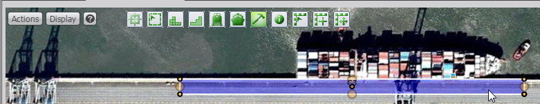
N4 uses a berth's water-facing direction to find the landside edges of the berth and the landside edges for 1-dimensional offset calculations of berths, bollards, and vertices. Visually, on the yard map, berths appear as rectangles. However, unlike yard blocks, the width (short dimension) of the rectangle does not represent physical space in the yard. Therefore, how wide or narrow you draw the rectangle is based only upon how wide you need it to be to see it in the yard map.
Use the Berth form to add a berth or to edit an existing berth.
Before you begin:
You must:
Have a berth model that exists in the Berth Models view (on page 1). If you do not have a berth model, follow the Create steps in Create or edit a Berth Model (on page 1).
Know your specific berth placement locations. To configure accurate geographic coordinates and yard paths that result in efficient operations, your site must have a precise CAD-enhanced image of your yard uploaded as the background for the yard map in Yard Editor.
Review all of the steps of this procedure.
Review and understand How to draw the berth (on page 1). This topic will help you identify how wide to draw the rectangle and complete step 3c.
To add or edit a berth:
In the Yard Editor view, select an inactive yard model.
Right-click the yard model and select Open Yard Editor...
In Yard Editor, position the yard map so that you can see the entire area occupied by berth.
Zoom in as closely as possible without cutting off any part of the berth area.
In the map area, locate the left-most point of the berth.
Decide how wide to draw the rectangle.
Select  (the Berth tool).
Click a point on the quay; your click point is dependent upon the following orientation information:
For berths where the line between the water and the land in the yard map is oriented approximately along the X (horizontal) axis (that is, with the water oriented above the land), do the following:
down-click on the insert point and,
without releasing the mouse
move your hand inland (downward if the water is at the top of the map) to the preferred width and,
move your hand to the right.
Release the mouse at the right-most point of the berth.
For berths where the line between the water and the land in the yard map is oriented approximately along the Y (vertical) axis, do the following:
down-click on the top right corner of the berth and,
without releasing the mouse,
move your hand left to the preferred width and,
move your hand downward.
Release the mouse at the bottom-most point of the berth.
See examples of both type of berth drawings in How to draw the berth (on page 1).
A dialog displays which asks whether you want to add a new or an existing berth.
If you imported a berth.txt file to automatically create your berth, select Existing. The Place Berth form appears, and displays the latitude and longitude of the berth's anchor point.
Verify that the coordinates of the anchor point are accurate.
In the Name field, select an existing berth.
Click Save.
The Place Berth form closes, and the berth appears on the yard map as a gray rectangle with the berth Name inside.
Select  (the Modify Block tool) and right-click the berth rectangle.
The Edit Berth form appears.
If you left-click the berth rectangle when the Modify Block tool is selected, the rectangle turns purple, and displays the coordinates in edit mode. When in edit mode, you can reposition the berth, or adjust the length or width.
If you are creating a new berth, select New. The Add Berth form appears, and displays the latitude and longitude of the berth's anchor point.
Verify that the coordinates of the anchor point are accurate
In the Name field, enter a name for the berth.
The value in the Name field must match the Quay Id in the Quay form in the topology. Y
In the Sequence field, enter the sequence number for the berth. This value is relative to the sequence numbers for all the berths in the berth model, and is required for mapping the two-dimensional berth layout in N4 to the one-dimensional berth layout in XPS.
For example, if the first berth from the leftmost start of the quay has a Sequence of 1, the second and third berths can have Sequence of 2 and 3, respectively, or 8 and 11. If there is a fourth berth, and the second berth had Sequence = 8, and the third berth had Sequence = 11, the fourth berth must have a Sequence value >11.
In the Meter Mark (m) field, enter the meter mark of the left boundary of the berth, in meters. Use a negative number if the meter mark decreases to the right.
If you imported the berths.txt file to create your berth model, this field already contains the value from your berths.txt file #BERTH "Mtr Mark" column.
Select the Show Conflicts check box if you want to view conflicts for this berth in the Berth Scheduler window in XPS.
From the Dynamic Traffic Mode list, select one of the following values:
Fore-to-aft: Traffic flows one-way from the fore of the vessel to the aft of the vessel.
Aft-to-fore: Traffic flows one-way from the aft of the vessel to the fore of the vessel.
None: Turns off the Dynamic Traffic Mode feature for this berth. Traffic is now determined by the traffic field.
If you select Fort-to-aft or Aft-to-fore, the traffic direction for that berth is determined by the berth orientation (direction) of the visiting vessel.
In the Facing Direction (deg) field, specify the berth's water facing direction angle, in degrees, with respect to compass true North in a clockwise direction. For an example, see How to draw the berth (on page 1). This information affects the driving direction for vehicles and the berthing direction for vessels.
An incorrect angle might result in a corrupted berths.txt file with, for example, incorrect berth 1-dimensional offsets or missing bollards.
When you add a new berth, you must enter a value for the Facing Direction (deg) field. However, if the berths.txt file that you imported to create your berth model did not include the Facing Direction (deg) field, this value will be missing.
If this berth is part of a pair, in the Paired Berth list, select the berth opposing this berth.
Click Save.